


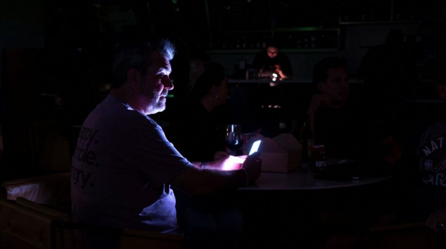
Scene from a hotel lobby during a power outage ahead of the arrival of Hurricane Isaias, in Pensacola, Florida, US, October 9, 2026. REUTERS/Marco Bello
മണിക്കൂറിൽ 175 കിലോമീറ്റർ വേഗതയിൽ വീശിയടിച്ച ‘ഇസയാസ്’ ചുഴലിക്കാറ്റ് യുഎസിലെ ഫ്ലോറിഡ തീരത്ത് കരതൊട്ടു. അതിതീവ്ര ചുഴലിക്കാറ്റ് വെള്ളി രാത്രിയോടെ ഫ്ലോറിഡയിലെ ഡെസ്റ്റിന് സമീപം പടിഞ്ഞാറൻ പാൻഹാൻഡിലിലാണ് ആഞ്ഞടിച്ചത്. ഇതേത്തുടര്ന്ന് ഫ്ലോറിഡ, അലബാമ, ജോർജിയ സംസ്ഥാനങ്ങളിൽ അടിയന്തരാവസ്ഥ പ്രഖ്യാപിച്ചു. ഈ മേഖലകളില് അനേകമാളുകളുടെ ജീവന് അപകടത്തിലാക്കാന് സാധ്യതയുള്ള കൊടുങ്കാറ്റും പ്രളയവും ഉണ്ടാകാൻ സാധ്യതയുണ്ടെന്ന് യുഎസ് നാഷണൽ ഹറിക്കെയ്ൻ സെന്റർ മുന്നറിയിപ്പ് നൽകി.

Debris is seen in an intersection as wind and rain from Hurricane Isaias pass through the area on October 09, 2026, in Pensacola, Florida. Hurricane Isaias is in the Gulf of Mexico as the season's first Atlantic hurricane. Joe Raedle/Getty Images/AFP (Photo by JOE RAEDLE / GETTY IMAGES NORTH AMERICA / Getty Images via AFP)
‘ഇസയാസ്’ കരതൊടുന്നതിന് മുൻപുതന്നെ മേഖലയിൽ കനത്ത നാശനഷ്ടങ്ങൾ റിപ്പോർട്ട് ചെയ്തിട്ടുണ്ട്. ചുഴലിക്കാറ്റിന്റെ ഫലമായി ഫ്ലോറിഡയിലും അയൽ സംസ്ഥാനങ്ങളിലുമായി അഞ്ച് ലക്ഷത്തിലധികം വീടുകളില് വൈദ്യുതി വിച്ഛേദിക്കപ്പെട്ടു. തീരദേശമേഖലകളിൽ ഒൻപതടി വരെ ഉയരത്തിൽ തിരമാലകള്ക്ക് സാധ്യതയുണ്ടെന്നാണ് മുന്നറിയിപ്പ്.
ചുഴലിക്കാറ്റ് നേരിട്ട് ബാധിക്കാൻ സാധ്യതയുള്ള തീരമേഖലകളിൽ നിന്ന് ഉടന് ഒഴിഞ്ഞുപോകാൻ ഫ്ലോറിഡ ഭരണകൂടം നിർദേശിച്ചു. അലബാമയിൽ വിനോദസഞ്ചാരികളടക്കമുള്ളവരോട് തീരദേശ കൗണ്ടികളിൽ നിന്ന് മാറാൻ ഗവർണർ കേ ഐവി ഉത്തരവിട്ടു. പ്രധാന നഗരങ്ങളിൽ കർഫ്യൂ ഏർപ്പെടുത്തിയിട്ടുണ്ട്.
A person walks through the wind and rain as Hurricane Isaias passes through the area on October 09, 2026, in Pensacola, Florida. Hurricane Isaias is in the Gulf of Mexico as the season's first Atlantic hurricane. Joe Raedle/Getty Images/AFP (Photo by JOE RAEDLE / GETTY IMAGES NORTH AMERICA / Getty Images via AFP)
പടിഞ്ഞാറൻ ഫ്ലോറിഡ പാൻഹാൻഡിലിലെ അഞ്ച് ലക്ഷത്തോളം പൗരന്മാര്ക്ക് അതീവ ജാഗ്രതാനിർദേശമായ 'എക്സ്ട്രീം വിൻഡ് വാണിങ്' പുറപ്പെടുവിച്ചു. എസ്കാംബിയ കൗണ്ടിയിൽ മാത്രം 70 ശതമാനത്തിലധികം വീടുകള് ഇരുട്ടിലായി. പെൻസകോള നഗരത്തിൽ വൈദ്യുതി ബന്ധം പൂർണമായും തകരാറിലായതായി മേയർ ഡി.സി. റീവ്സ് വ്യക്തമാക്കി. മോശം കാലാവസ്ഥയെത്തുടർന്ന് വാൾട്ടൻ കൗണ്ടിയിൽ അറ്റകുറ്റപ്പണികൾ താൽക്കാലികമായി നിർത്തിവെച്ചിരിക്കുകയാണ്.
'ലെവൽ 4' പ്രളയ സാധ്യത
ഫ്ലോറിഡയുടെ ബിഗ് ബെൻഡ് മേഖലയിലും തെക്കൻ ജോർജിയയിലും അപകടകരമായ രീതിയിൽ കനത്ത മഴ പെയ്യാൻ സാധ്യതയുണ്ടെന്ന് കാലാവസ്ഥാ കേന്ദ്രം മുന്നറിയിപ്പ് നൽകി. അപൂർവമായി മാത്രം പുറപ്പെടുവിക്കുന്ന അതീവ അപകടസാധ്യതയുള്ള ‘ലെവൽ 4’ പ്രളയ മുന്നറിയിപ്പാണ് ഇവിടെ നൽകിയിരിക്കുന്നത്. മണിക്കൂറിൽ 3 മുതൽ 6 ഇഞ്ച് വരെയും, തുടർച്ചയായി പെയ്യുന്ന ഇടങ്ങളിൽ 10 ഇഞ്ചിലധികവും മഴയ്ക്ക് സാധ്യതയുള്ളപ്പോഴാണ് ഈ മുന്നറിയിപ്പ് നല്കുന്നത്.
GOES-19 GeoColor satellite image provided by the National Oceanic and Atmospheric Administration (NOAA) and taken at 1:06 p.m. EDT, Friday, Oct. 9 2026, shows Hurricane Isaias approaching the Gulf Coast of Alabama and Florida . (NOAA via AP)
കരതൊട്ട ശേഷം ഇസയാസ് ചുഴലിക്കാറ്റിന്റെ കേന്ദ്രം അലബാമ കടന്ന് ശനി, ഞായർ ദിവസങ്ങളിലായി ടെന്നസി താഴ്വരയിലേക്ക് നീങ്ങുമെന്നാണ് നാഷണൽ വെതർ സർവീസിന്റെ നിഗമനം. കൊടുങ്കാറ്റിനൊപ്പം ചില പ്രദേശങ്ങളിൽ ചുഴലിക്കാറ്റുകൾ രൂപപ്പെടാനും സാധ്യതയുണ്ടെന്ന് മുന്നറിയിപ്പുണ്ട്.
പസഫിക് സമുദ്രത്തിലെ എൽ നിനോ പ്രതിഭാസത്തെ തുടർന്ന് അറ്റ്ലാന്റിക് സമുദ്രത്തിലെ ചുഴലിക്കാറ്റ് സീസൺ വൈകിയിരുന്നു. 30 വർഷത്തിനിടെ ആദ്യമായാണ് ഒക്ടോബർ വരെ അറ്റ്ലാന്റിക്കിൽ ഒരു ചുഴലിക്കാറ്റ് പോലും രൂപപ്പെടാതിരിക്കുന്നത്. ഇസയാസിന് പുറമെ നോർത്ത് അമേരിക്കൻ തീരങ്ങളിലേക്ക് മറ്റ് രണ്ട് കൊടുങ്കാറ്റുകൾ കൂടി അടുത്തുവരുന്നുണ്ട്